So guys, Have you checked these Twin Hurricanes/Typhoon that attacks East-Asian?
http://www.weather.com/storms/typhoon/news/goni-atsani-guam-saipan-west-pacific-typhoons
Today, I will tell you how these Hurricanes formed :
Why should we understand Hurricane?
You can see that the hurricanes give great impact to human life .... One of great Disasters that affect a lot of System for Human. Here's the examples :
 |
| Is it Tsunami's? No, it's hurricane's! |
 |
| Is it Tsunami's? No, it's hurricane's! |
 |
| Is it Tsunami's? No, it's hurricane's! |
 |
| Is it Tornado's? No, it's hurricane's! |
This is why you should Understand how Hurricane works to prevent and decrease our Vulnerability :))
Definition of Hurricane
So, Hurricane/Tropical Storm/Typhoon, based on wikipedia :
A tropical cyclone is a rapidly rotating storm system characterized by a low-pressure center, strong winds, and a spiral arrangement of thunderstorms that produce heavy rain. Depending on its location and strength, a tropical cyclone is referred to by names such as hurricane, typhoon , tropical storm, cyclonic storm, tropical depression, and simply cyclone.
(summitcountryvoice.com)
There are several condition to form a Tropical Storm :
1. At least, having 26.5 celcius sea surface temperature on the depth of 60 m or more.
This condition would support a low-pressure area growth that on the first step would be signed as "Tropical Disturbance". Tropical Disturbance having only a slight circulation with no closed isobars around an area of low pressure. (Yes you can see a lot of Cumulonimbus and other strong convective!).
This condition would make moist Atmosphere because a lot of Evaporation and Latent heat release on the atmosphere. These latent heat would be an Energy Resource to drive the growth of Tropical Storm! These latent heat release, would make a Low-pressure areas above the Atmosphere, and yes, it will drive the wind to form the rotation wind and support the growth of Convective cloud especially Cumulonimbus.
 |
| Phase 1 of Hurricane |
2. At least, having 5 degree distance from the Equator.
Have you heard Coriolis Effect? Yes, it's literally related with that! Coriolis will support the rotation of Tropical Storm. And this condition, is one of Benefit in Indonesia. Yes, Almost every region on Indonesia would be safe from these Tropical Storm possibilities.
In physics, the Coriolis effect is a deflection of moving objects when the motion is described relative to a rotating reference frame. (en.wikipedia.com)
Coriolis Effect is pseudo-force, the only reason it appears is just the Earth Rotation. But still, although this force is Pseudo, you can't leave it, and you should calculate it, literally. And this is one of Reason why on Tropical Country, it's really hard to predict the Weather. Imagine on 0 lat, There is no Coriolis Effect, right? .... Is it ? Really? Literally zero? (A question that need to be answered)
(http://oceanexplorer.noaa.gov)
And this would cause :
 |
| Hurricane spins on Boreal and Austral hemisphere |
Got it? The spin direction of hurricanes would be different on boreal (north) or austral (south) hemisphere
3. Having stable wind against altitude that will support the Growth of Thunderstorm (Thanks to the first requirment that will support this Atmosphere condition!). The more Heat on the ocean, the more stable the winds above it !
So, there is one Question : If Hurricanes moves north, Should it be more faster?
Answer : Logically, yes. But still, the most important thing is SST. If hurricane moves north, it means it would loss more Energy, because the SST would be getting Colder. And it means, the Hurricanes would die soon, if it gets into the colder ones. Hurricanes would die soon, if it moves to the Continent. Why? Once again, it needs Energy that came from the Ocean. From the latent heat release, right? Of course it would die soon on continent ....
Kak (Bro).... Why did you say that Hurricanes is A Mechanism to Balance the Earth?
Dek (Sist).... Have you realized? If there's no Hurricanes, the equator would be getting warmer and warmer, while on the North, the SST are much colder. To balance it, earth needs mechanism, and Hurricane is one of the Answer! ONE OF, which means, there are a lot of phenomenon that's a part of Earth's mechanism.
So, if the Climate Change/Global warming is real, Earth would often use these Mechanism to balance it, which means, more Hurricanes, more anomalies, and yes, More Disasters for us! So? Let's save the Earth !
So guys, maybe that's all I could explain. If you have any question and further information, you can mail me on rafi_hariri@students.itb.ac.id :) Thank you !
- Proud to be Meteorologist! -
Hello guys ! These are several works that has been done by Climate Policy group 3 to campaign about Saving the Energy !
First, you should know "Why is it important to us to Reduce the GHG Emission?"
The answer is simple !
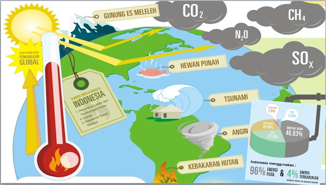
Have you heard Climate Change? I bet you have heard about it, at least understand what climate change is. We can define Climate as an average condition of weather on the Long term (at least 30 years) to re-evaluate it. Basically climate refers to the average condition of the Weather by evaluating several Meteorology parameter such as Temperature or Rainfall. Climate change closely related to the Global Warming. If we see the average temperature of the Earth, you will see there's an increasing pattern exponentially that indicate we're having Global warming right now. The effect? Wah, a lot of things! You may see the increase of Tropical Typhoon phenomenon (Because typhoon is one of Earth's mechanism to balance the temperature on Earth !), extreme weather that will increase Flood or drought even, El-Nino, La-Nina or a lot of Global Anomali events, forest-fire, changing the pattern life of Animal (for example : Bird and Caterpillar life pattern, you may check the IPCC report), agriculture, and many aspects of Life !
 |
| Illustration of Climate Change Effect around the world |
Actually, it's easy to get involved to the Movement, even by changing the way of our life.
 |
| Saving energy campaign for climate policy class 1 |
What have you got? It's still the beginning! You may do the second and third part, but .... You may do these as well !
Saving Energy !
 |
| Saving energy campaign for climate policy class 2 |
 |
| Saving energy campaign for climate policy class 3 |
 |
| Saving energy campaign for climate policy class 4 |
 |
| Saving energy campaign for climate policy class 5 |
 |
| Saving energy campaign for climate policy class 6 |
Let's Calculate !
Assume every lamp has 10 watt power, if we use it for 1 hour, the emission would be 9.51 g CO2 (Woah, it seems small .... but wait!). If we assume that every student use the lamp for 10 hour (could be more, thought), the total emission would be 95.1 g CO2, right? If there are 12000 ITB students, then the emission would be (1141.2 Kg CO2). One year? Congratz ! ITB Students has produced ..... 416.538 Ton CO2. Okey, FYI, the age of CO2 on Atmosphere is about 150 years, so, if we produce 416.538 Ton CO2 today, it will dissapear on 2165. It's great, right? That's why we need you ! To get involved by changing a simple way of life .... Let's Save the Energy !
Although if you save 1 hour or reduce 9.51 g CO2, Imagine if ..... Everyone do it? We're literally saving the Earth, ok?
Using Alternative Vehicles
So, after having Intern on Ministry of Environmental and Forestry, I do realize that Transportation is one of the biggest problem on Indonesia policy. Even transportation is second Ranked for the GHG Emission based on the Badan Lingkungan Hidup Daerah data. This is why, it's important to tell you how to get involved through this Issue. And honestly, it's easy to do something about it !
Check it out!
 |
| Saving energy campaign for climate policy class 7 (My poster!) |
Well, this is one of mine. I must say that, as a student, if I go to campus by walking, I could save more than 4000 rupiah and Yes, it helps me a lot ! No need to pay Gases, ticket, and yes there's no Traffic at all! And of course it could make you more Healthy, save money, and SAVE THE EARTH!
CAR SHARING
 |
| Saving energy campaign for climate policy class 8 |
There is one more way to save the Earth, if you think that it's hard to walk or biking .... Car sharing is the Best one! Well, not only saving the Earth, you could make more friends, ecpanding your network, Silaturahmi, you won't be bored to ride alone, and etc.
3R (Reduce, Reuse, Recycling)
Like transportation, Liquid or Solid waste is one of the biggest issues through GHG Emission on DKI Jakarta. What you need to do is simple, by doing 3R, you could save the energy through the Production. And yes, you can save more money and having clean Environment!
 |
| Saving energy campaign for climate policy class 9 |
So guys, that's several thing we could do to get involved this movement .... Stay good and share it if you care, Global warming is one of Greatest Issue that need to be resolved, and we need you, you, and you to Save the Earth for our next Generation. Bye !
Based on Wikipedia,
El Niño is the warm phase of the El Niño Southern Oscillation
(commonly called ENSO) and is associated with a band of warm ocean
water that develops in the central and east-central equatorial Pacific
(between approximately the International Date Line and 120°W), including off the Pacific coast of South America.
El-Nino is an Anomali that happens on Walker Circulation (One of global circulation that has role on Weather pattern on Earth).
So, It's easy to understand what driven this phenomenon. First, you can Imagine there are a "warm pool" across pacific, that could be shifted to eastern or western area. Because it's kind of a cycle, we can't say "Who's first ?" (kind of "Who's first? Egg or Chicken?"). But, you can say that Indonesia is the main Actor here.
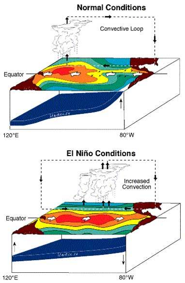
El-Nino happens when the "warm pool" shifts eastward along the equator, toward pacific ocean. Normally, this "warm pool" near Indonesia and the Philippines.
But during an El Niño, the Pacific's warmest surface waters sit offshore of
northwestern South America. When this warm pool shifts to Nino 3,4, or 3.4 (it's kind of coordinates across pacific ocean), this is gonna affect the pressure on the areas. We know that this "warm pool" gonna make an Low-Pressure Areas, and will create its own circulation ! (Wind blows from High to Low Pressure, right?)
You can see this Picture to compare it yourself
 |
| Normal vs El-Nino Condition |
See? There are shifting on Convective Areas. And one of greatest effect for "Indonesia", is Indonesia could be Draught and Fire-forest could happen because of it.
Why did I use quotation mark on Indonesia?
So guys, you should understand that Indonesia is a Big Word.
Generally, you may say that "Indonesia" may be affected by El-Nino. But .... not really.
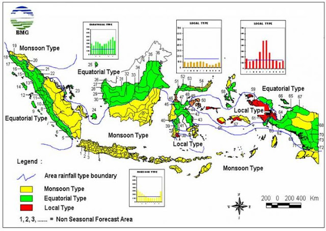
Indonesia, have 3 kind of climate-pattern based on Rainfall peaks.
1. Monsoon Pattern
The Areas with this pattern, usually have a great different between Wet and Dry season. It's clearly driven by Monsoon phenomenon, that happens because of ocean-continent temperature distribution. Eastern Monsoon would bring a lot of water from the Indian-ocean and pacific ocean, different with western Monsoon that's not really carrying moist water across Australian continent and indian-ocean.
2. Equatorial Pattern
The areas within this pattern, usually have 2 rainfall peaks because of the Sun position. We know that, Equator areas would be have 2 Equinox a year, that makes evaporation through Equatior should be maximized and for several areas, it affects them a lot.
3. Local Pattern
Basically, local pattern seems like Monsoon pattern but vice versa. It happens because the local geographic condition (usually happens on the areas near Mountain) because Orography effect.
 |
| Indonesia Season Map (source: BMKG) |
Generally, we can see Indonesia's pattern here. But, even if we Zoom into Bandung, West Java, we could see this pattern !
 |
| Rainfall Map of DAS Citarum Hulu (Source: Pemkot Bandung) |
Believe it or not, the center one has Monsoon Pattern, where the yellow one has Equatorial Pattern, and the orange one has the local pattern because its mountain area. We still need a lot of Research to creat climate Map on many Indonesia Areas. Because Indonesia, is really complicated one, and this makes us, Meteorologist, hard to predict the accurate Weather because the Scheme that's not really fit with Indonesia Geographic position.
Back to the Topic, El-Nino does affect "Indonesia", but you must Specify where the Area is, because not all of Indonesia areas be affected with it. Even when El-Nino happens now, Bogor still have some extreme storm currently.
I think that's all for tonight. Hope this could give you a lot of Information about El-Nino and La-Nina that's happening lately :)
Follow Me @rafi_haririInstagram


