Does El-Nino Affect Indonesia?
Based on Wikipedia,
El Niño is the warm phase of the El Niño Southern Oscillation (commonly called ENSO) and is associated with a band of warm ocean water that develops in the central and east-central equatorial Pacific (between approximately the International Date Line and 120°W), including off the Pacific coast of South America.El-Nino is an Anomali that happens on Walker Circulation (One of global circulation that has role on Weather pattern on Earth).
So, It's easy to understand what driven this phenomenon. First, you can Imagine there are a "warm pool" across pacific, that could be shifted to eastern or western area. Because it's kind of a cycle, we can't say "Who's first ?" (kind of "Who's first? Egg or Chicken?"). But, you can say that Indonesia is the main Actor here.
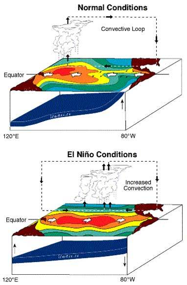
El-Nino happens when the "warm pool" shifts eastward along the equator, toward pacific ocean. Normally, this "warm pool" near Indonesia and the Philippines. But during an El Niño, the Pacific's warmest surface waters sit offshore of northwestern South America. When this warm pool shifts to Nino 3,4, or 3.4 (it's kind of coordinates across pacific ocean), this is gonna affect the pressure on the areas. We know that this "warm pool" gonna make an Low-Pressure Areas, and will create its own circulation ! (Wind blows from High to Low Pressure, right?)
You can see this Picture to compare it yourself
 |
| Normal vs El-Nino Condition |
Why did I use quotation mark on Indonesia?
So guys, you should understand that Indonesia is a Big Word.
Generally, you may say that "Indonesia" may be affected by El-Nino. But .... not really.
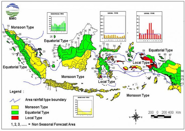
Indonesia, have 3 kind of climate-pattern based on Rainfall peaks.
1. Monsoon Pattern
The Areas with this pattern, usually have a great different between Wet and Dry season. It's clearly driven by Monsoon phenomenon, that happens because of ocean-continent temperature distribution. Eastern Monsoon would bring a lot of water from the Indian-ocean and pacific ocean, different with western Monsoon that's not really carrying moist water across Australian continent and indian-ocean.
2. Equatorial Pattern
The areas within this pattern, usually have 2 rainfall peaks because of the Sun position. We know that, Equator areas would be have 2 Equinox a year, that makes evaporation through Equatior should be maximized and for several areas, it affects them a lot.
3. Local Pattern
Basically, local pattern seems like Monsoon pattern but vice versa. It happens because the local geographic condition (usually happens on the areas near Mountain) because Orography effect.
 |
| Indonesia Season Map (source: BMKG) |
 |
| Rainfall Map of DAS Citarum Hulu (Source: Pemkot Bandung) |
Back to the Topic, El-Nino does affect "Indonesia", but you must Specify where the Area is, because not all of Indonesia areas be affected with it. Even when El-Nino happens now, Bogor still have some extreme storm currently.
I think that's all for tonight. Hope this could give you a lot of Information about El-Nino and La-Nina that's happening lately :)


0 komentar: